Colorado Trip from San Antonio, TX to Rocky Mountain National Park, CO

sikkemarn

Member
Hi Heartland Family,

We are planning our first trip to Colorado, we recently purchased 2016 Big Horn 3750F,our tow vehicle is a 2011 F350 Diesel truck, we need lot's of advice:

We have never driven in the mountains, any suggested routes for novice drivers?

Should we buy a GPS specific for RV travel, and if so what brands?

What sights should we visit on our way back to Texas?

All your advice would be greatly appreciated.
 

JohnD

Moved on to the next thing...
I think the easiest drive to RMP without all of the mountain driving would be to take I-25 north the Loveland, Colorado at the HWY 34 exit and take that west to Estes Park.

Very popular place so you'll want to make your campground reservations soon!

We also like to camp on the other side of RMP in Grand Lake and enter the park from that side.

By the way . . . you don't want to pull your trailer through RMP.

Stay on either side and drive the truck only through the park!

I have a Rand McNally/Good Sam RV gps and like all of the poi's that are geared toward RV'ing!
 

jstarwal

Well-known member
Good advice JohnD. I second the Rand McNally gps/Good Sam.
If you get close go to Glenwood Springs.

Jack & Lynette
 

StarryNight

Retired Colorado Chapter Leaders
We are both from San Antonio (grew up there) and have lived here in Denver-metro for the past 27 years. We have been driving back and forth to SA and Houston for many, many years....with that said... Will RMNP be your only stop here in Colorado? How much time will you have overall for your trip? Are you thinking of visiting New Mexico and the west Texas area or to the north and visit Oklahoma and Kansas?
The answers to these questions will help with suggesting a route :)

Monica & Don
 
Last edited:

sikkemarn

Member
Thanks everyone keep the advice coming, we have allowed a total of 18 days round trip, leaving TX end f June. We have planned for 4 days in the Colorado Springs area Including 4th of July) and 4 days in RMNP area, we are staying at Jellystone Park in Estes. Mountaindale RV park in Colorado Springs, Any suggestion for the trip back home (would like to take a different route home, more sites in Colorado headed back home, thought about a day or two in New Mexico. Rand McNally GPS seems very expensive, is it really worth it? I appreciate all of your feedback

- - - Updated - - -

StarryNight, had not thought about KS or OK, wants to see as much of CO as possible, which route should we take when leaving RMNP rather than back tracking the same way we came. Thanks for all of your advice. Colorado Springs area and RNMP so far are on the list, looking to add another 3-4 day pit stop and site see.
 

Shortest Straw

Caught In A Mosh
There really are not many ways to get into RMNP with a fiver. IMO the best way to get to Estes is Hwy 34 through Loveland.
 

StarryNight

Retired Colorado Chapter Leaders
Thanks everyone keep the advice coming, we have allowed a total of 18 days round trip, leaving TX end f June. We have planned for 4 days in the Colorado Springs area Including 4th of July) and 4 days in RMNP area, we are staying at Jellystone Park in Estes. Mountaindale RV park in Colorado Springs, Any suggestion for the trip back home (would like to take a different route home, more sites in Colorado headed back home, thought about a day or two in New Mexico. Rand McNally GPS seems very expensive, is it really worth it? I appreciate all of your feedback
We have tried several routes going and coming...but prefer I-10 W to Junction, US83 N to Eden, US87 to Lubbock, I-27 to Amarillo, US 287/87 to Dumas, US87 to Raton (New Mexico), I-25 N.
Why do we like this route? Shortest distance & fastest route. The surrounding landscape is so much nicer than going thru Oklahoma/Kansas. There are nice places to stay & visit along the way.
Places in Texas along this route that you can stop & explore: Palo Duro Canyon State Park(have a really neat stage show during the summer), Caprock Canyon State Park(state bison herd)...San Angelo State Park is nice if there has been a wet spring...but during July it is rather hot. We were there in July a few years ago and it was 107 F...needless to say the AC was running full time!
Places in southern Colorado to check out: Great Sand Dunes National Park (there are several campgrounds in the area) We stayed in Alamosa KOA and went to the Dunes as well as Zapata Falls as a day trip.
The only mountain pass you will need to "tackle" on this route is Raton Pass. It's....well, it's a pass...both of us have driven it, you just have to be aware of your surroundings. There won't be snow that time of year :) You'll start out going 55mph (we do not tow faster than 55-60) and end up going 30 at the top(ha,ha). Going down the Colorado side the road is a bit more windy (turns in road) than the New Mexico side.
We have taken I-25S to I-10E and gone thru El Paso (I have a brother that lives in Alpine, TX) and then on to SA (this is a longer route). New Mexico has the VLA (Very Large Array) west of Socorro on US60, Valley of Fires east of Socorro on US380 both are interesting to visit. Then there's Carlsbad Caverns National Park in southeastern New Mexico and Guadalupe National Park in Texas.

I realize this is a lot to digest...if you have any questions please do not hesitate to ask :)

Monica

As far as leaving RMNP and not backtracking...why not?
No matter which route you decide to take to Colorado...You will be making a "bee-line" to Colorado Springs and then going straight to RMNP. If you go back via I-25S then you can check out the Great Sand Dunes NP and Alamosa area and maybe even go on the Rio Grande Scenic Railroad train ride while you are in Alamosa. (While you are at Mountaindale/Colorado Springs you can go see the Royal Gorge, Pikes Peak and Garden of the Gods.)
 

sikkemarn

Member
This is great info, I am so excited, but a little apprehensive about the driving, you have given me some relief, now about a GPS, do we need to invest in one. Your advice has been so helpful our route is somewhat similar, SA to Abilene, Abilene to Dalhart, Dalhart to Colorado Springs, live somewhat south of San Antonio. Do you have any advice on which GPS to purchase?
 

JohnD

Moved on to the next thing...
Do you have any advice on which GPS to purchase?

I have the Rand McNally 5510 . . . was $200 on sale at Camping World, but didn't come with Lifetime Maps ($80), but I did purchase the maps.

The next model up is $350, has a larger screen (7" vs 5"), and comes with Lifetime Maps.

Make sure to get an 'RV' gps as it is geared more for the RV'er than a passenger car, and has many POI's (points of interest) that are RV related.

Like campgrounds, state and national parks, RV service centers and dealers, gas stations and truck stops . . . that kind of stuff.

Plus you can download custom POI's, like Walmart stores, Camping World, restaurants (by name), free wifi and much more!
 

Rollin_Free

Well-known member
While we're also just starting our Sundance experience I have a strong opinion regarding GPS systems. I really like the models mentioned however when I purchased my last vehicle GPS I purchased one with free lifetime map upgrades and traffic alerts. IMO these are by far the most important feature a GPS can have available. Knowing if a route has issues of any kind really takes the stress off the drive to get somewhere.

Having a GPS with lifetime maps and traffic alert would be primary features I will be looking at when we do purchase a RV type unit.
 
Last edited:

danemayer

Well-known member
One GPS feature that you'll find worth the expense is lane guidance for your upcoming exit. On a busy interstate like I-25 in the Denver area, or on interstates around many larger cities in Texas, it's very helpful to have early notification of which lane to be in. We have used the Garmin RV760 for a few years and love it.

If a good RV GPS is out of your budget at the moment, but you have an iPad or Android Tablet, take a look at the GPS CoPilot app. For $10 or $15 you can have a large display with clear route details, markers for each 1/10 of a mile, and voice guidance. Your tablet has to have a GPS chip for it to work - iPads with WiFi only may not. You can try out the free version of the app to see if you like it.
 

StarryNight

Retired Colorado Chapter Leaders
This is great info, I am so excited, but a little apprehensive about the driving, you have given me some relief, now about a GPS, do we need to invest in one. Your advice has been so helpful our route is somewhat similar, SA to Abilene, Abilene to Dalhart, Dalhart to Colorado Springs, live somewhat south of San Antonio. Do you have any advice on which GPS to purchase?

Since there are two ways to leave Dalhart and go to ColoradoSprings (US87 to Texline, Clayton OR US 385 to Boise City, OK) and I don't know which route you are planning...be aware of the railroad tracks you need to go under in Dalhart...it is 13'7". Our BH is 13'2" at its highest point when level. We have gone under the tracks many, many times but each time we do it just scares the *** out of me!! It doesn't bother Don...anyway just be aware of this and be sure you measure your rig at the highest point. The signs that are posted for this particular "limited clearance" railroad track are not big and do not have any kind of flashing light but they are posted several miles before it and right when you get about 1/8 mile (or so) away.
 

JohnD

Moved on to the next thing...
Another route to consider would be taking Highway 7 (called the Peak To Peak Highway) from Estes to Nederland, then down Boulder Canyon to Boulder, and from there you can take Highway 36 back to Denver, then south.

We looked at the Jellystone Campground a couple of years ago when we were out scouting for campsites in Estes Park.

It looked pretty nice, but as I recall, the park was rather hilly and the sites rather tight.

We wound up finding a nice site right next to the river at Manor RV Park on the west side of town.

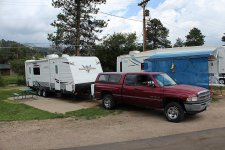
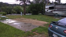
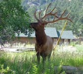
EstesPark-IMG_2845.jpg ManorRVEstesPark-IMG_20140608_154058177.jpg EstesParkElk2014-IMGP0732.jpg

First shot us getting ready to head home, second shot the day we were scouting sites, third shot was a 14-pt elk walking along the river shot from our campsite.
 
Top